Property Record
223 Shiloh Unity Rd, Lancaster, SC 29720
NEARBY LISTINGS FOR SALE OR LEASE
-
-
View all Lancaster listings for sale on LoopNet.com
Property Detail
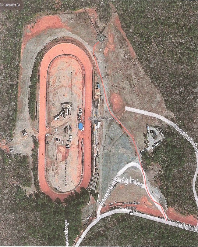
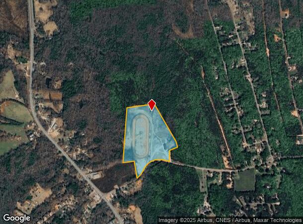
223 Shiloh Unity Rd
0049-00-064.00
Lancaster
Commercialnec
South Carolina
X
41.72 AC
45023C0150C
Lancaster County
2024
Charlotte
2024
Charlotte-Concord-Gastonia, NC-SC
011002
DEMOGRAPHICS near 223 Shiloh Unity Rd
1 Mile
3 Mile
5 Mile
2024 Total Population
882
6,075
21,074
2029 Population
1,062
7,336
25,467
Pop Growth 2024-2029
+ 20.41%
+ 20.76%
+ 20.85%
Average Age
45
45
41
2024 Total Households
354
2,478
8,608
HH Growth 2024-2029
+ 20.34%
+ 20.78%
+ 20.89%
Median Household Inc
$69,945
$61,634
$49,563
Avg Household Size
2.40
2.40
2.40
2024 Avg HH Vehicles
3.00
2.00
2.00
Median Home Value
$223,016
$222,464
$191,905
Median Year Built
1985
1985
1978
Nearby Places
Map Layers
Map Styles
 Street
 Aerial
- Restaurants
- Banks
- Shops
- Fitness
- Groceries
SALE & LEASE HISTORY
LISTING DATE
SALE/LEASE

Feb 15, 2017
For Sale
Nearby Properties
Address
Land Use
TOTAL SIZE
Lot Size
Zoning
Address
Land Use
TOTAL SIZE
Lot Size
Zoning
20,023 SF
9.79 AC
INS
Address
Land Use
TOTAL SIZE
Lot Size
Zoning
61,875 SF
5.74 AC
CITY
Address
Land Use
TOTAL SIZE
Lot Size
Zoning
53.69 AC
CITY
Address
Land Use
TOTAL SIZE
Lot Size
Zoning
84.28 AC
Address
Land Use
TOTAL SIZE
Lot Size
Zoning
28,260 SF
5.57 AC
GB
Address
Land Use
TOTAL SIZE
Lot Size
Zoning
3,688 SF
66.09 AC
INS
Address
Land Use
TOTAL SIZE
Lot Size
Zoning
5,804 SF
3.33 AC
INS
Address
Land Use
TOTAL SIZE
Lot Size
Zoning
1,235.50 AC
MDR
Address
Land Use
TOTAL SIZE
Lot Size
Zoning
35,177 SF
33.86 AC
GB
Address
Land Use
TOTAL SIZE
Lot Size
Zoning
16,128 SF
29.08 AC
INS
Address
Land Use
TOTAL SIZE
Lot Size
Zoning
56.85 AC
RA-40 UNIO
Address
Land Use
TOTAL SIZE
Lot Size
Zoning
3,392 SF
6.79 AC
CITY
Address
Land Use
TOTAL SIZE
Lot Size
Zoning
2,936 SF
6.80 AC
CITY
Address
Land Use
TOTAL SIZE
Lot Size
Zoning
3,285 SF
11.20 AC
INS
Address
Land Use
TOTAL SIZE
Lot Size
Zoning
4,706 SF
2.72 AC
LDR
Address
Land Use
TOTAL SIZE
Lot Size
Zoning
25.02 AC
RA-40 UNIO
Address
Land Use
TOTAL SIZE
Lot Size
Zoning
5,800 SF
7.99 AC
INS
Address
Land Use
TOTAL SIZE
Lot Size
Zoning
34,680 SF
6.81 AC
Address
Land Use
TOTAL SIZE
Lot Size
Zoning
6,160 SF
6.98 AC
INS
Address
Land Use
TOTAL SIZE
Lot Size
Zoning
3.64 AC
Address
Land Use
TOTAL SIZE
Lot Size
Zoning
46,990 SF
35.35 AC
GB
Address
Land Use
TOTAL SIZE
Lot Size
Zoning
3,080 SF
18.57 AC
RN
Address
Land Use
TOTAL SIZE
Lot Size
Zoning
1.82 AC
PB
Address
Land Use
TOTAL SIZE
Lot Size
Zoning
7,789 SF
3.40 AC
INS
Address
Land Use
TOTAL SIZE
Lot Size
Zoning
1,200 SF
3.11 AC
RA-40 UNIO
Address
Land Use
TOTAL SIZE
Lot Size
Zoning
4,580 SF
6.24 AC
LDR
Address
Land Use
TOTAL SIZE
Lot Size
Zoning
130.11 AC
MDR
Address
Land Use
TOTAL SIZE
Lot Size
Zoning
37.78 AC
OSP
Address
Land Use
TOTAL SIZE
Lot Size
Zoning
19,212 SF
10.30 AC
GB
Address
Land Use
TOTAL SIZE
Lot Size
Zoning
3.85 AC
INS
The World's #1 Commercial Real Estate Marketplace
Connect with us
© 2025 CoStar Group
The information above has been obtained from sources believed reliable. While we do not doubt its accuracy we have not verified it and make no guarantee, warranty or representation about it. It is your responsibility to independently confirm its accuracy and completeness. Any projections, opinions, assumptions, or estimates used are for example only and do not represent the current or future performance of the property. The value of this transaction to you depends on tax and other factors which should be evaluated by your tax, financial, and legal advisors. You and your advisors should conduct a careful, independent investigation of the property to determine to your satisfaction the suitability of the property for your needs.